Some lost cities exist only in stories. Others lay waiting under sand or sea until someone looked. Pick one below.
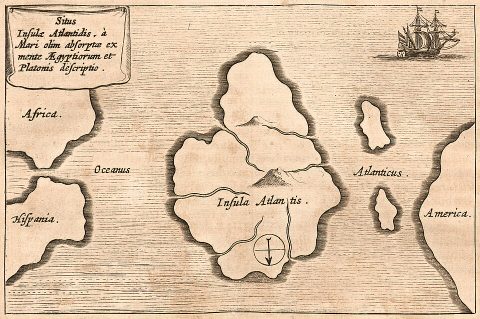
Everything we know about Atlantis comes from two dialogues by Plato, the Timaeus and the Critias, written around 360 BCE. There, a character tells how Egyptian priests described a mighty island empire beyond the Pillars of Heracles that attacked Athens some 9,000 years earlier, was defeated, and then sank into the sea in a single day and night.
No earlier Greek writer mentions Atlantis, and most scholars read it as a philosophical story Plato invented to illustrate his ideal state and the danger of pride, much as he invented other myths in his dialogues. Real events may have given him ideas, such as the volcanic eruption of Thera (Santorini) in the second millennium BCE or the sinking of the Greek city of Helike in 373 BCE. Since the 19th century, people have “located” Atlantis almost everywhere on Earth; none of these claims has held up.
Source: Plato’s Timaeus and Critias, c. 360 BCE
Story: An island empire sunk in a day and night
Scholarly view: Mostly a philosophical myth by Plato
Darshniks’ Take: Atlantis comes from a single philosopher who used invented myths to teach. Read Plato for the moral about pride and power, not as a map.
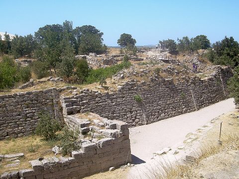
For centuries many people assumed Homer’s Troy was pure legend. In the 1860s Frank Calvert, and from 1871 the German businessman Heinrich Schliemann, dug at the mound of Hisarlik in north-western Turkey. Schliemann found layer upon layer of cities built on top of one another, and gold he grandly named “Priam’s Treasure”, though it turned out to be about a thousand years too old for the Trojan War.
Schliemann dug so aggressively that he destroyed much of the evidence. Later excavators identified at least nine main cities on the site. Layers known as Troy VI and VIIa, from the late Bronze Age, show signs of a large, wealthy city that was damaged around 1200 BCE, and Hittite texts mention a place called Wilusa that many scholars identify with Troy. Whether a war like Homer’s ever happened is still debated, but the city was real.
Site: Hisarlik, north-western Turkey
Excavated: From 1871 (Schliemann); still studied
Verdict: Real city; Homer’s war unproven
Darshniks’ Take: The city was real; whether Homer’s war happened as told is still open. It is a good example of a legend with a real place at its core.
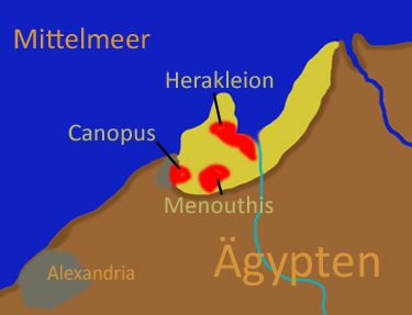
Ancient writers mentioned a port city called Heracleion at the mouth of the Nile, where Herodotus said Helen and Paris stopped on their way to Troy. For a long time it was thought to be little more than a name.
In 2000 the French underwater archaeologist Franck Goddio and his team found it in the Bay of Aboukir, about 6.5 kilometres off the coast, beneath 10 metres of water. They recovered colossal statues, temple remains, gold coins and dozens of shipwrecks. The city, also called Thonis in Egyptian, had been Egypt’s main Mediterranean port before Alexandria. It sank gradually as the soft ground beneath it gave way, helped by earthquakes and floods.
Found: 2000, Bay of Aboukir, Egypt
Depth: About 10 m under the sea
Was: Egypt’s great port before Alexandria
Darshniks’ Take: A city known only from ancient writers turned out to be real and waiting under the sea. Patient underwater survey beat centuries of speculation.
Just off the coast of Laconia in southern Greece, in water only a few metres deep, lie the streets, houses and tombs of a town called Pavlopetri. It was spotted in 1967 by the oceanographer Nicholas Flemming and mapped soon afterwards.
Surveys from 2009 using modern sonar and mapping showed it was inhabited from around 3000 BCE through the Bronze Age, making it one of the oldest known submerged towns in the world. It sank gradually as the land subsided. Its layout of streets and buildings is unusually complete, a rare chance to see a whole Bronze Age town plan.
Where: Off Laconia, southern Greece
Discovered: 1967
Age: Occupied from about 3000 BCE
Darshniks’ Take: One of the oldest submerged towns known, with its streets still visible. Real sunken cities are usually quiet places like this, not lost super-civilisations.
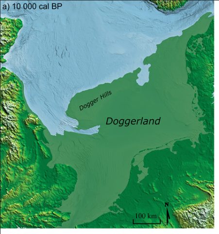
During the last Ice Age, so much water was locked in ice that the sea floor between Britain and mainland Europe was dry land. Archaeologists call this lost landscape Doggerland: a region of hills, rivers, marshes and lakes where people hunted and fished for thousands of years.
As the ice melted, rising seas slowly drowned it, and by around 6500 to 6000 BCE most of it lay under the North Sea; a huge undersea landslide off Norway, the Storegga Slide, sent a tsunami across the region around 6200 BCE. Fishing boats still drag up mammoth bones and stone tools from the sea bed. Doggerland is a real lost world, and a warning about how much rising seas can take.
Where: Under today’s North Sea
Drowned: Mostly by c. 6500–6000 BCE
Evidence: Bones, tools and seabed mapping
Darshniks’ Take: A genuine lost world under the North Sea, drowned by rising seas. Its lesson about climate change is uncomfortably relevant.
In 1864 the English zoologist Philip Sclater proposed a sunken land bridge, which he called Lemuria, to explain why lemur fossils and lemurs are found in Madagascar and India but not in between. Occultists later turned Lemuria into a lost continent of an ancient race.
In the late 19th and 20th centuries some Tamil writers linked Lemuria with old Tamil traditions of land lost to the sea, recorded in medieval commentaries on the Sangam literature, and called it Kumari Kandam, the cradle of Tamil civilisation. Plate tectonics later explained the scientific puzzle without any sunken continent: India and Madagascar were once joined and drifted apart. Real sea level rise did drown coastlines after the Ice Age, but there is no evidence for a vast lost continent in the Indian Ocean.
Lemuria proposed: 1864, Philip Sclater
Tamil version: Kumari Kandam, lost southern land
Science today: Explained by continental drift
Darshniks’ Take: A powerful story in Tamil cultural memory, but not supported by geology; continental drift explains what the lost-continent idea was invented to explain. Real coastlines did change, and that history is worth studying.
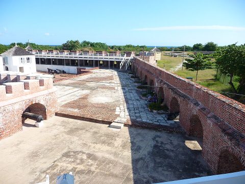
In the 17th century Port Royal, on the coast of Jamaica, was one of the richest and most notorious towns in the Americas, a base for English privateers and pirates. On 7 June 1692 a powerful earthquake caused much of the town, built on loose sand, to slide into the harbour. Around 2,000 people died in the disaster, and more in the sickness that followed.
Underwater excavations from the 1960s onwards found streets and buildings remarkably preserved, including a pocket watch said to have stopped at 11:43, the time of the quake. It is often described as a “sunken city” frozen at a single moment of the late 17th century.
Sank: 7 June 1692, earthquake
Where: Kingston Harbour, Jamaica
Known as: A town frozen in time underwater
Darshniks’ Take: A town swallowed in minutes in 1692 and preserved underwater. A real disaster, with a real lesson about building on loose ground.
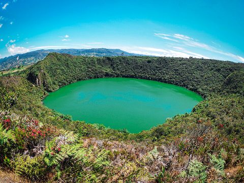
El Dorado began not as a city but as a man: “the gilded one”. Spanish chroniclers heard that among the Muisca people of the Colombian highlands, a new ruler was covered in gold dust and floated out on a raft to Lake Guatavita, where gold offerings were thrown into the water. A famous gold model of such a raft, the Muisca raft, was found in 1969.
The story grew into a legend of a whole city of gold hidden in the jungle, and expedition after expedition, including Sir Walter Raleigh’s in 1595 and 1617, ruined lives and lands searching for it. Attempts to drain Lake Guatavita found some gold objects but nothing like the fortunes imagined. The ceremony was real; the city of gold was a dream fed by greed.
Origin: Muisca ceremony at Lake Guatavita, Colombia
Real evidence: The gold Muisca raft (found 1969)
City of gold: Never existed
Darshniks’ Take: The Muisca ceremony was real; the city of gold was a fantasy that drove destructive expeditions. Greed made a ritual into a myth.
Lost-city stories fascinate because they hint that our world rests on forgotten ones. Sometimes they are right: Troy, Heracleion and Doggerland were all real. But a story being old is not the same as a story being true, and the real discoveries came from patient digging and diving, not from decoding legends.
Atlantis on Wikipedia · Thonis-Heracleion on Wikipedia · Doggerland on Wikipedia